Compare 576 Travel Destinations
7 of 576 guides match

American Southwest
United States
A road-trip region of red-rock canyons and impossibly wide skies — Grand Canyon's South Rim, Sedona's crimson buttes, Antelope Canyon's light shafts, Horseshoe Bend, and Monument Valley's towering mesas. Flagstaff and Sedona anchor most itineraries; a rental car is mandatory and the distances are bigger than they look.
Belize
Belize
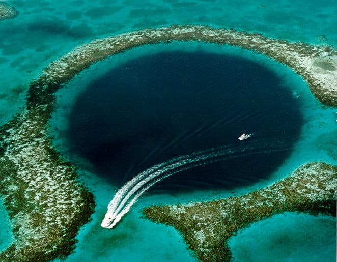
The only English-speaking country in Central America — Caribbean coast on one side, Guatemalan jungle on the other, the world's second-largest barrier reef just offshore. The 124m-deep Great Blue Hole anchors the offshore atolls and decorates the country's banknotes; Ambergris Caye is the model for Madonna's "La Isla Bonita"; tiny car-free Caye Caulker takes the "Go Slow" mantra so seriously that they painted it on signs. Inland, the ancient Maya pyramids of Caracol, Xunantunich, and Lamanai rise from jungle reserves, and Actun Tunichil Muknal cave still holds skeletal sacrifices from a thousand years ago. English-speaking, BZD pegged 2:1 with USD, and one of the least-visited adventure paradises in the Caribbean.

Cape Cod
United States
Cape Cod is the 65-mile hooked arm of Massachusetts that defines the New England summer for most of the East Coast. The Cape Cod National Seashore protects 44,000 acres of dune, marsh, and Atlantic beach from Eastham to Provincetown at the tip; the 22-mile Cape Cod Rail Trail runs the spine of the Lower Cape on a converted rail bed; and Hyannis is the ferry hub for day trips to Martha's Vineyard and Nantucket. Six loose regions (Upper, Mid, Lower, Outer, plus Falmouth and Sandwich) each have their own character. The catch: Friday and Sunday traffic over the Sagamore and Bourne bridges can add two hours to a trip.

Lake Atitlán
Guatemala
Aldous Huxley called it "the most beautiful lake in the world." Three volcanoes ring a 1,562m caldera, and twelve Maya villages dot the shoreline — each Kaqchikel or Tz'utujil with its own character. Panajachel for transit, San Pedro for backpacker partying and Spanish school, San Marcos for yoga and cliff jumps, Santiago for traditional culture and the Maximón shrine, San Juan for textile co-ops and coffee. Lanchas (boats) shuttle between them.

Napa Valley
United States
Northern California's premier wine region — a 30-mile-long, 5-mile-wide valley an hour north of San Francisco that contains over 400 wineries and produces 4% of California's wine while generating 27% of the state's wine value. The 1976 'Judgment of Paris' blind tasting put Napa on the world map when a French jury rated Stag's Leap Wine Cellars Cabernet Sauvignon and Chateau Montelena Chardonnay above their celebrated French counterparts — Time magazine called it 'the day Napa Valley earned its place.' The first American Viticultural Area outside Augusta, Missouri (1981), the valley now contains 16 sub-AVAs each with distinct soil and microclimate. Cabernet Sauvignon dominates at ~55% of plantings, supported by daily marine fog rolling in from San Pablo Bay through the Petaluma Gap and a 40°F+ diurnal temperature swing. Anchored by Napa town in the south and St. Helena and Calistoga in the north along the SR-29 'Wine Route,' with the parallel Silverado Trail offering a quieter alternative. The 1989 Napa Valley Wine Train still runs vintage Pullman dining cars 36 miles round-trip at 18 mph past vineyards. Closest airports: Oakland (OAK) and SFO.

Outer Banks
United States
The Outer Banks are a 200-mile chain of barrier islands off North Carolina, strung from the wild horse beaches of Corolla in the north through Kitty Hawk, Nags Head, Hatteras, and ferry-only Ocracoke. Cape Hatteras Lighthouse (198 feet, the tallest brick lighthouse in the United States) anchors the middle of the chain, the Wright Brothers National Memorial in Kill Devil Hills marks the spot of the first powered flight in 1903, and the Cape Hatteras National Seashore protects 70 miles of undeveloped Atlantic beach. This is a quieter, fishing-and-family vacation coast, not a boardwalk-and-arcade one.

Viñales
Cuba
A UNESCO-listed valley in Cuba's tobacco-growing Pinar del Río province, three hours west of Havana, where flat-topped limestone mogotes rise like sleeping giants over fields of red earth. Days here run on country time. Horseback rides slip between rows of curing tobacco at family vegas, classic Plymouths and Buicks ferry travellers along Calle Salvador Cisneros, and farmers like the Robaina dynasty open their drying barns for free hand-rolled cigar tastings. Cueva del Indio threads an underground river through limestone, the giant Mural de la Prehistoria covers a cliff face, and casa particular homestays put guests at the family table for fresh-pressed sugarcane juice and yuca con mojo.